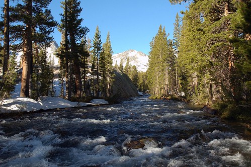
© Harold Davis – Rush Creek crossing, early morning, July 3, 2005
This is the third (and final) installment of a story about my recent short — but particularly poorly planned — backpacking trip to the Ansel Adams Wilderness in the high Sierra in this year of extraordinarily heavy snowpack. You can read about how I got into this in first place in A Walk on the Wild Side, and how I dug myself further in: Does the Wilderness Care about Me? Here’s also a topographic trail map of the area if you really want to follow my travails on (and off) the trail.
The walk down the trail from my campsite at Summit Ridge to the Pacific Crest Trail junction and then up to the John Muir Trail junction at the inlet to Thousand Island Lakes was not particularly dangerous. However, my assessment that I had made it through to the end of the snow fields was, of course, premature. As soon as the trail wandered down below timberline into the forest, it vanished under snow that hadn’t melted. Starting up to Thousand Island Lakes, I passed once more in a territory of snow, rock, water, and raging hot sunshine. My 40 SPF all-day sun stuff worked pretty well, but my lips were blistering and the inside of my nose was getting sunburnt.
Here’s a picture of Thousand Islands Lake (as I’ve said, you’ll just have to believe that there are really islands under that snow!):
I sat down, got my bear canister out of my back, and took out some jerky and nuts to have for a late lunch. I also pulled off my socks to dry (the constant snow got in my boots, and I was walking with ice-water wet feet).
Finally, I had a look at the map to see what to do next. I didn’t really want to camp at the lake in the snow, although I could have been comfortable. It was more an emotional thing than anything else. I felt that I wanted to be sure that I could make it out of there.
It seemed from the map that my best bet was to cross Island Pass, which is a relatively low pass at 10, 205 feet, head down into the Rush Creek valley, turn east and follow the trail beside the creek down past Waugh Lake, Billy Lake, Gem Lake, and finally to Agnew Lake — which was where I had come up beside the cog railway. From Agnew Lake it was a short couple of miles down the cliffside to the trailhead at Silver Lake — and, yes, my car!
Although I noted a couple of creek crossings, this looked reasonably unproblematic, although far longer than my route into the wilderness. I was about to get my boots back on and saddle up when a couple of hikers came up along the trail from the south. They were “Batchelor Bob” and “Beer-Keg Ben”. I don’t know where these nicknames came from, but it’s how they introduced themselves. Batchelor and Beer-Keg were in their early twenties and “through-trekkers” — heading on the Pacific Crest Trail from Mexico to Canada. Batchelor carried an ice ax and wore gators. He said, “These gators don’t do any good, my feet still get wet. I’ll die happy if I never see another one of these four feet high snowcups from Hell!”
Snow cups are formed when the snow fields melt in the afternoon. The process of slogging through a snow field in the afternoon is repeatedly climbing up and down over these formations, which as Batchelor rightly said can only been devised by the devil in an inventive mood. Every so often when you are crossing these things in the late afternoon when they are getting melty you go through up to your waist. You can only hope that you are not crashing through to an under-snow pit or raging snow-melt river. It just takes a great deal of energy to get across a field filled with these crusty snow cells.
Beer-Keg Ben was carrying, of all things, a beach umbrella. He said, “I don’t see how anyone crosses 600 miles of desert [along the Pacific Crest Trail near the Mexican border] without carrying one of these things. It’s good on snowfields too.”
We talked about how the snow had slowed them down. Bob and Ben needed to average close to thirty miles a day to reach the Canadian border before October. They said they couldn’t wait for Oregon: “It’s always summer there, we can hike in tank tops and leave the winter gear behind, and rally make tracks.” Well, I don’t think so, but I wish these guys luck.
Bob and Ben headed up in the direction they thought was towards Island Pass. However, they were mistaken about which way to go (they were headed east over a cliff!) and I had to set them straight. We said good bye a second time, and pretty soon I was on the trail behind them, and not too much later the trail vanished under the snow and Bob and Ben’s tracks were gone for good.
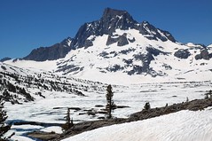
To call Island Pass a pass is a little peculiar. Actually, it’s a high, mostly above-timberline plateau complete with a number of small lakes and a bunch of mini-summits. Without a trail, in the snow, navigation was confusing. Here’s a picture of conditions:
Once I figured out that the trail probably headed round the shoulder coming down from Mount Davis, I didn’t have much problem with picking a general route. But steep slopes, afternoon sun cups, ice water traps and rocky ridges made progress treacherous and slow. I could see Donahue Pass, the Yosemite Park border, at over 11,000 feet a good bit higher than Island Pass, under snow in the distance.
I really can’t convey how weird and disorienting it was to navigate around this area. A number of times I went a fairly good distance before climbing to a vantage point and realizing that I had gone off course. You can imagine that a loud exclamation preceded each course correction! But, of course, course correcting was better than heading straight ahead down some snowy cliffs.
After going on the diagonal around a particualrly steep slope, I reached a little rocky summit that I really thought was the further edge of the pass. I was morally certain — which means about 95% — that I had done a good job in coming out where the trail did. What concerned me as I looked out over the valley below was the positively ferocious noise of falling water. Water crashing, roaring, water formed of afternoon ice and snow melt, making a positively cruel noise down below. I hadn’t really thought much before about river crossings, and now I began hoping that there were bridges!
I shambled down the slope with my ice-water feet, and felt positively in awe of myself when I emerged from the snow about fifty feet from the Muir Trail. Holy cow I said to myself, I’m good.
The terrain at the bottom of the valley was a kind of weird stone labyrinth with piers of stone surrounded by twisting water courses that had overrun their banks. When I got to the first crossing, there was a rough plank bridge made of logs that had been cut so they were flat and then chained together (there’s a picture in this blog entry of mine).
After crossing, the trail followed the further bank of the creek, although mostly the trail was either flooded or covered with snow. I picked my way wearily down to the junction with the trail that crossed Rush Creek and would take me home, only to find the creek so high that it could not be safely crossed (the picture is at the top of this story installment).
By now I was so tired that I figured I ought to make camp and deal with it in the morning. I slept soundly, but anxiously, with dreams of falling and pounding water.
In the morning, the water was down several feet, and I thought I had a chance to make it across. (I really couldn’t think of any decent alternatives). I reloaded my pack so that the cameras and other digital gear were as high up as possible. I put my hiking boots on without socks, and slowly started out into the icy, tumultuous creek.
Stepping into the cold, rushing water was frightening, and I couldn’t really see how deep it was. At each step I tried to plant my feet so that I wouldn’t be buffeted down stream, or slip. I often couldn’t tell through the foam where I could step next, or whether there were slippery rocks. I didn’t know whether the water at some point in the crossing would be over my neck.
In fact, the water was no higher than my waist, but you can hardly imagine the force of the snow-melt fed torrent against me even this high. I’m fairly certain that I could only have made it across in the early morning, and that by late afternoon it would have been impassable for a single hiker.
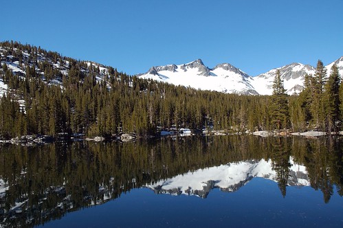
I can report, as you’d expect since I am writing this, that I made it across. More surprisingly, the cameras made it dry. I put my socks back on, and began the long slog down to the trail head. There was one more difficult and wet crossing (the inlet to Waugh Lake), and after that it was a sunny walk beside placid lakes (the trail was still going through mud holes and snow banks, but nothing too difficult compared to what I’d already passed through). Here’s a picture of reflections of snow back in the high country in Waugh Lake:
I had a good, hard look from across Agnew Lake at the cliff I started out by climbing, noticing particualarly the waterfall pouring out from beneath a snow field I had crossed, and called myself an idiot. (See the first part of this story.)
It was late afternoon before I reached my car (I entertained and motivated myself along the way with meditations on food and sex).
In the fews days since I had started on my hike, a volunteer ranger (meaning this was some kind of part time retirement job), his wife, and poodle had moved into a trailer behind a little booth by the trail parking lot. The ranger’s RV had a BBQ in back, surrounded in a neat triangle with astro turf.
Before I drove away, I knocked on the door of the volunteer ranger’s trailer, told him about back country conditions, and suggested he might want to discourage people from following my route (at least without proper snow and ice equipment).
Next stop was the Bad Man from Bodie BBQ Restaurant in Lee Vining for a whole rack of ribs (I did mention that they have a thing about naming food and food establishments after miners in the eastern Sierra – good for tourism, or something).
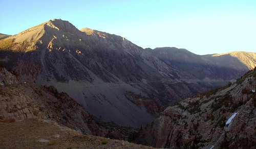
It was now about 8PM and the sun was a beautiful, setting orange ball. I headed up the magnificant road above Vining Canyon towards Tioga Pass:
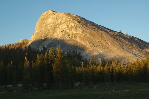
As evening turned to night along the Tioga Road I passed Lembert Dome:
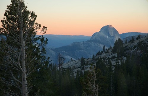
And then I saw Half Dome from Olmsted Point:
Finally there was the long drive home through the night, first the dark North Yosemite Highway, then the towns and bustling two-lane roads of California’s central valley, and eventually the freeways of the Bay area megalopolis.
I got home at about 3AM and parked in the garage. I crept upstairs quietly. The house was dark. Phyllis and the boys were sleeping. I showered, and crawled into bed. Phyllis turned over, and touched me. “Oh,” she said, “You’re back.”
I felt like Max, the hero of Where the Wild Things Are. Max is naughty, and sent to bed without supper, where he travels
in and out of weeks
and almost over a year
to where the wild things are
Eventually, he grows bored with being the king of all wild things:
and sailed back over a year
and in and out of weeks
and through a day
and into the night of his very own room
where he found his supper waiting for him
and it was still hot.
In the night air of the sleeping house my family was still there and I was happy!
This concludes my story, which began in A Walk on the Wild Side
My story was continued in Does the Wilderness Care about Me?
Pingback: Photoblog 2.0: » Photoblog 2.0 Archive: » A Walk on the Wild Side
Pingback: Photoblog 2.0: » Photoblog 2.0 Archive: » Does the Wilderness Care About Me?
Pingback: Photoblog 2.0: » Photoblog 2.0 Archive: » A Lost Hiker
Pingback: Photoblog 2.0: » Photoblog 2.0 Archive: » Mono Lake Is for the Birds and Brine Flies
searsr
4 Nov 2005Harold,
Thanks for your story. I had a similar incident in Yosemite this summer in Jack Main Canyon. I knew a number of dangerous things I did (number one being backpacking alone for 3 days), and your insight has pointed out a few more that I wasn’t counting in my list of things that should have killed me. Days later I ended up on the Ficery SAR which really drove home the chances I took. Hopefully I’ve learned my lesson. Glad you’re safe- keep taking beautiful nature pics!
Becky
Harold Davis
5 Nov 2005Hi Becky – Thanks for your wonderful comment. I did want to know, what is Ficery SAR?
Best wishes,
Harold
searsr
7 Nov 2005Harold,
Sorry, SAR is the Search And Rescue for Michel Ficery (missing backpacker you mention).
Becky
Pingback: Photoblog 2.0: » Photoblog 2.0 Archive: » Midnight Rambles