
On a balmy afternoon in late October I studied the topographic map of the USGS San Francisco North Quadrant. This map shows (among other areas) the hills above Fort Baker outside Sausalito, and the northern side of the Golden Gate Bridge.
It seemed to me that there was a ridge that could be climbed going up from above Fort Baker. You can tell on a topo map if something is steep when the contour lines on either side of the white space representing the ridge top are spaced close together. If the contour lines aren’t drawn too closely across the top itself, there’s a good chance you can get up.
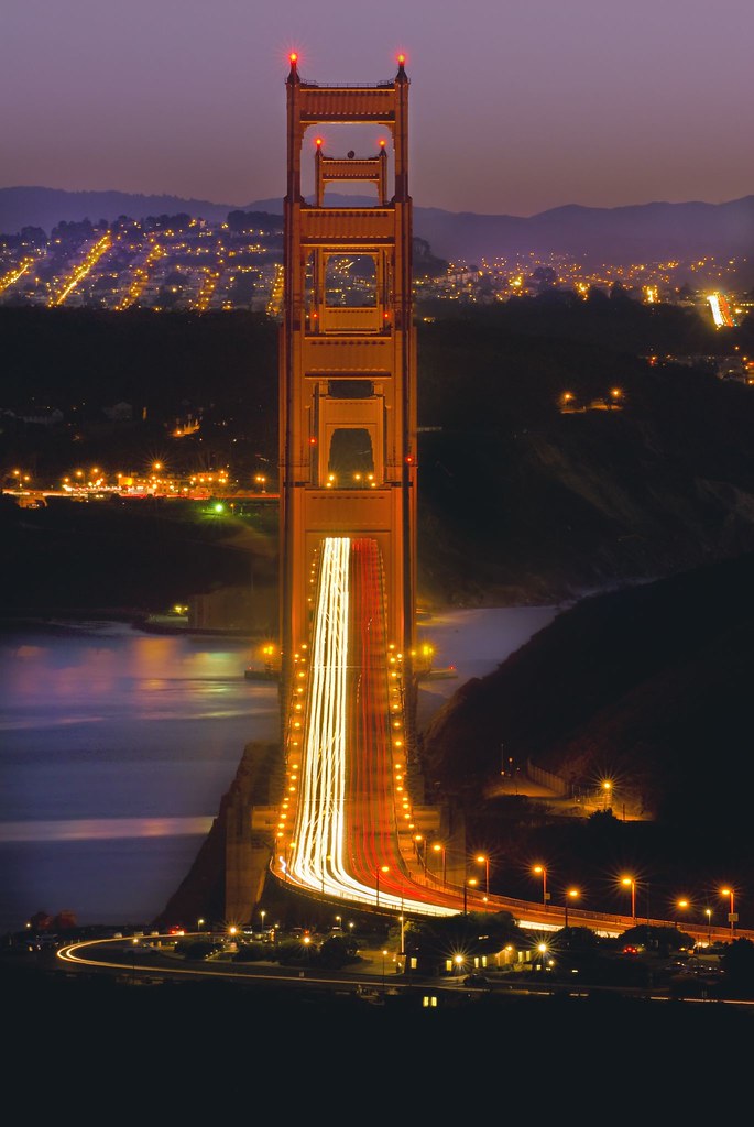
My hope was to find a location across from the northern end of the Golden Gate Bridge so that I could shoot through both towers.
I picked up my friend Mark and we parked on Wolf Back Ridge Road, high above Sausalito. Technically, this is a private, no-trespassing area carved into the Marin Headlands section of the Golden Gate National Recreation Area.
We donned our hiking boots and backpacks, and scrambled down a steep hill to find the Coastal Trail. Heading south, we passed a high tension tower, and then trudged up the hill over the Waldo tunnel. From there, I could see a straight shot down the ridge I had observed on the topo quadrant map.
The ridge line ended on a rock platform. Yes, the towers of the bridge aligned perfectly from north to south. The setting sun lit the bridge from the west, and the waxing moon provided fill lighting from the other side.
I positioned my camera on the tripod, braced it with my camera backpack to keep it from vibrating in the wind, and exposed for thirty seconds. The time exposure turned the car headlights and tail lights into lines of light beneath the bridge in alignment.
[230mm in 35mm terms, 30 seconds at f/20 and ISO 100, tripod mounted.]
Pingback: Photoblog 2.0: » Photoblog 2.0 Archive: » Above the Waldo Tunnel
Pingback: Photoblog 2.0: » Photoblog 2.0 Archive: » Point Bonita Lighthouse
Pingback: Photoblog 2.0: » Photoblog 2.0 Archive: » Cars