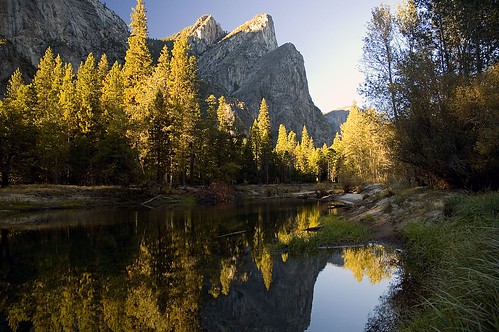
There and Back Again!

I’m just back from a week trip to the mountains and the desert.

Phyllis is a saint and took care of the three kids more-or-less solo. I think Julian wanted to come with me so much that he really was acting out. Handling the three of them at once is no piece of cake for one person.

I visited Yosemite, the eastern Sierra, and the desert.

On this trip I took over 1,000 images, and as time goes by I’ll be processing and blogging the best of them. I’m very excited by these photos, but they are stark.

The purpose of the entry is to explain in an overview fashion where I went.

If you look at the map, you can see I first drove to Yosemite, where I spent several days hiking. (You can click on the map or here to see it in a larger size.)

there be dragons

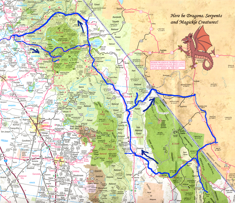
After Yosemite, I went over Tioga Pass and into Owens Valley.

I drove south down Owens Valley, stopping to take pictures, and then turned east towards Westgard Pass, the ancient Bristlecone Pines, and the desert.

From Beatty, Nevada I explored the ghost town of Rhyolite, and then entered Death Valley National Park.

I returned to Owens Valley near Lone Pine, watched the sunrise shed morning alpenglow on Mount Whitney, and spent several sessions photographing the Alabama Hills.

Turning north, I headed for Bridgeport, photographed Twin Lakes, and had a straight shot home over Sonora Pass.

This is the macro picture. Stay tuned for more photos, and stories of my travels in more detail.

map of USA

Keep in touch with what Harold is doing! For news, tips, techniques and special offers related to Harold's work and digital photography subscribe to the Harold Davis Photography email newsletter.

The Photoshop Darkroom: Creative Digital Post-Processing Creative Composition: Digital Tips & Techniques 100 Views of the Golden Gate Creative Close-Ups: Digital Tips & Techniques


Harold buys most of his digital photo equipment from B&H.

15 Responses to “There and Back Again!”

  1. Photoblog 2.0: » Photoblog 2.0 Archive: » Dark is the Valley in the Morning Says:

    [...] hy: techniques: thoughts: photographs: Harold Davis

    « There and Back Again!

    Dark is the Valley in the Morning

    .flickr-phot [...]

  2. Photoblog 2.0: » Photoblog 2.0 Archive: » Processing a Photo for Flickr Says:

    [...] 1973/” title=”photo sharing”> Lake Tenaya Reflections, photo by Harold Davis. On my trip, I left Yosemite Valley and drove across Tioga Pass. (I’ll write more about this segment [...]

  3. Photoblog 2.0: » Photoblog 2.0 Archive: » The Hitchhiking Millionaire Says:

    [...] ns, photo by Harold Davis. Leaving the waterfalls of Yosemite behind, I continued with my trip. The sun was just reaching the trees, as in this picture, when I drove through the Valley on m [...]

  4. Photoblog 2.0: » Photoblog 2.0 Archive: » Risk Management Says:

    [...] s it was recently after I headed over Tioga Pass and before I went down into Owens Valley (view a map of my trip). Despite fairly heavy usage — on a summer weekend there will likely be hu [...]

  5. Photoblog 2.0: » Photoblog 2.0 Archive: » The Deepest Valley Says:

    [...] avis. After reluctantly leaving Hot Creek, I headed down Route 395 into Owens Valley. (View road map of my route here.) Between the Sierra crest on the west rising to heights above 14,000 f [...]

  6. Photoblog 2.0: » Photoblog 2.0 Archive: » Beyond Westgard Pass Says:

    [...] sert country of basins, ranges, and valleys. (View a map of the area towards the bottom of my first story in this series.) Westgard Pass is closed to commercial trucking (the road is too narrow [...]

  7. Photoblog 2.0: » Photoblog 2.0 Archive: » Seeking Methuselah Says:

    [...] untains on the eastern side of Owens Valley. (View a map of the area towards the bottom of my first story in this series.) These trees grow best in harsh conditions where it’s hard for o [...]

  8. Photoblog 2.0: » Photoblog 2.0 Archive: » Rhyolite and Ozymandias Says:

    [...] own at the eastern entrance to Death Valley. (View a map of the area towards the bottom of my first story in this series.) Once Rhyolite was a bustling metropolis with a three story shopping, c [...]

  9. Photoblog 2.0: » Photoblog 2.0 Archive: » Death Valley Sunrise Says:

    [...] made fetid and stale by old tobacco smoke. (View a map of the area towards the bottom of my first story in this series.) Before the sun was up the next morning I was on my way west on Nevade [...]

  10. Photoblog 2.0: » Photoblog 2.0 Archive: » Lonely Road Says:

    [...] is/53783148/” title=”Photo Sharing”> You can view a map my trip towards the bottom of my first story in this series.

    This entry was posted

    on T [...]

  11. Photoblog 2.0: » Photoblog 2.0 Archive: » Mount Whitney Sunrise Says:

    [...] ” title=”Photo Sharing”> You can view a map of my recent travel towards the bottom of my first story in this series.

    This entry was posted

    on T [...]

  12. Photoblog 2.0: » Photoblog 2.0 Archive: » Zabriskie Quilt Says:

    [...] raphing sunrise from near Hells Gate. You can view a map of my trip towards the bottom of my first story in this series. The landscape at Zabriskie Point, with its folds and crevasses and clif [...]

  13. Photoblog 2.0: » Photoblog 2.0 Archive: » Digital Storage in the Field Says:

    [...] of my recent trip to Yosemite, Owens Valley, and the desert. It’s pretty similar to another image that I blogged at the beginning of my series of stories about this trip. So here’s [...]

  14. Photoblog 2.0: » Photoblog 2.0 Archive: » Road Trip Wrap-Up Says:

    [...] res and words about my autumn trip to Yosemite, the eastern Sierra, and Death Valley. There and Back Again! [...]

  15. Photoblog 2.0: » Photoblog 2.0 Archive: » Golden Wonder Says:

    [...] y in very early morning from Leidig Meadow looking northeast towards Middle Brother (shown here from the other side on a clear autumn afternoon) while Julian played in the snow. If you look care [...]

Leave a Reply

You must be logged in to post a comment.